New Orleans: The History of An American City
Original Publication Date: September 2007
this is where caption would go
FRENCH SETTLEMENT
The French, along with the other European powers, extended their settlement of the Western Hemisphere throughout the seventeenth century [Figure 1]. They first arrived at the islands of the Caribbean and then extended their interests to the North American continent. The French settled in Canada and then continued southward. By 1700, it was clear that they needed an outpost at mouth of the all important Mississippi River [Figure 2] but there was not a location close enough to the Gulf of Mexico that was not prone to flooding. By using the narrow inlet of Bayou St. John [Figure 3b], the distance between the two bodies of water was made shorter and easier for overland transportation of cargo and canoes. The natural levees along the river provided sufficient drainage and accessibility.
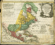
The site of New Orleans was first settled by the Choctaws in 1699, literally an island formed as the portage met the river. The French needed to secure the area for more than just economic reasons. The Spanish wanted to expand their holdings in the Southern portion of the continent, so the French established themselves in New Orleans in 1718 [Figure 2]. In the early years of the city, the terrain determined its growth. Each time the river overflowed, it left sediment on its banks, forming a natural levee that extended back one to two miles. Further away from the banks, softer materials settled, resulting in swamp and sludge. Only the poorest inhabited this area. Land closest to the river was the most desirable in terms of trade, transportation and safety.
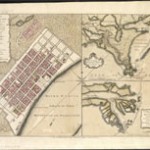
Over the next forty years, the natural levee was enhanced and by 1727 a four foot high bulwark stretched along the waterfront. French companies oversaw this construction. By the 1750s, the city covered a 66 block area [Figure 3]. New Orleans was urban and European from the start. The territory, named Louisiana in honor of the French king, was a mercantile colony, so the interests of the Crown and the private owners merged. The needs of the colony were best served by a large, forced labor system and slavery became integral to its economic success. The city also grew with the natural settlement of the Ohio River Valley to the north [Figure 6]. During the 18th century, rivers were the best mode of transportation in the growing colonies. The French built a canal to connect Bayou St. John to the natural levee. The initial purpose of this construction was drainage but eventually boats began to unload cargo at the end of the canal. This basin would become the site of waterfront commerce [Figure 3].
By end of Seven Years War in 1763, French power in North America weakened as the British exerted their dominance in the northern areas [Figure 5]. King Louis XV gave the Louisiana territory to Spain, ruled by his cousin. By the end of the eighteenth century, as Napoleon rose to power, he was determined to reassert French authority in the Western hemisphere. He planned to use French possessions in the Caribbean [Figure 9] as a base to expand his influence onto the continent west of the Mississippi, still held by Spain. Napoleon negotiated a secret treaty with Spain in 1800 that returned lands in the Louisiana territory to the French. Included under the terms of this treaty was the port city of New Orleans.
AMERICAN ACQUISITION
The importance of New Orleans to the growing American nation was clear. Residents of the new nation were rapidly populating areas west of the original thirteen colonies [Figure 6]. All rivers were vital to the transportation and trade that would enable the young country to thrive. Particularly problematic was the law imposed by the French in 1802 that prohibited the long standing practice of American ships using the port of New Orleans to transfer cargo from the Mississippi to ocean going vessels. President Jefferson did not wish to engage the powerful French army in a military conflict but his political base, farmers in the growing western portion of country, insisted on a resolution. Jefferson gave the French ambassador, Robert Livingston, instructions to purchase the city. Facing his own expansionist problems in Europe, Napoleon offered the entire territory to Jefferson. The American president had some questions regarding the constitutionality of territorial acquisition in this way, but yielded to the higher principal of providing room for an expanded arena that would enable his republican vision of the nation to flourish.
By the terms of the treaty, the United States would pay France $15 million dollars. France, in turn, would receive certain exclusive commercial privileges at the port of New Orleans and the residents of the Louisiana territory would be incorporated into the US with the same rights and privileges as other citizens. Inclusion of these Europeans helped contribute to the international sensibilities of the city. From the beginning, New Orleans was always more than a locality but a federal city. In existence for over a century by the time of its purchase in 1803, New Orleans was the fifth largest city in the nation per the 1810 census. There was also an arrogance to the metropolis, proud of it French and Spanish roots, deeming them far superior to the British origins of other American cities. New Orleans was foreign in design, culture, and attitude.
The port was central to its existence and to this day, manufacturing has never been a primary economic activity. The expanding America did not easily conquer this foreign city, whose international character was reinforced because it served as an important point of entry for the nations of South America and Europe. This centrality was often undermined by the physical reality of frequent flooding. Under French and then Spanish rule, the crown had provided these safeguards but now, in the democratically elected United States, the parish government was responsible for flood protection, a task which they passed onto landowners. The result was a haphazard and inconsistent system of flood protection. The city of New Orleans also taxed ships that used its waterfront to generate the revenue necessary to help maintain the levee system. The reality was that a larger, more coordinated effort was necessary. Problems in one portion of the river would have repercussions elsewhere, but state and federal initiatives were slow in coming.
NINETEENTH CENTURY
The United States of the nineteenth century was a story of expansion. The Mississippi River was more than geographically central in the North American continent. It was also at the core of the growing nation’s ability to extend itself. The advent of the steamboat made river travel dominant in the first half of century. In the decades before the Civil War, New Orleans was the primary trading spot of the seemingly unlimited bounty of the South—rice, sugar and cotton. The city’s population doubled in the first ten years after its acquisition. The Battle of New Orleans, although technically occurring after the end of the War of 1812, had enormous symbolic value as the city was able to withstand the British onslaught and defend American interests.
The city would not fare as well a half century later. Its general status as an economic rather than a political entity, as well as its location, made New Orleans important to both the North and South. By capturing the city, Union forces were able to cut off a major supply portal to the South [Figure13]. Even after the conflict ended, its stagnation during the war had a lasting impact. But New Orleans was already a city vulnerable to competition from railroads and the increasing importance of manufacturing to the nation’s wealth. The urban centers of industrialization, especially Chicago and St. Louis, overshadowed the city whose port remained its most vital economic organ.
As the city grew and expanded, settlement patterns were directed towards the natural levee. River frontage was important but scarce, so the result was fan shaped landholdings, with a small section of riverfront. The best land was upriver from the original city [Figure 10 or 12] and populated by wealthy slaveholders. The poorest whites lived in the swamp land inland from the riverfront. Racial settlement patterns were typical of the slave south, where there was a close proximity between the servants and their masters. Emancipation did little to change the racial residential realities of New Orleans.
The city grew in concentric circles and all sectors were affected by topography. The two biggest problems were flooding and drainage. The problems of the Mississippi River were literally and figuratively beyond the control of New Orleans, despite efforts to tax both planters and shippers to generate the revenue necessary to erect flood protection walls. By the 1840s, the state of Mississippi created the office of State Engineer to oversee public works and flood prevention, which meant construction and maintenance of levees. The Federal government assumed authority in 1879 as it established the Mississippi River Commission. River floods were only part of the problem. Lake Pontchartrain [Figure 10] also overflowed with great frequency.
The insufficient gradient of the city led to the other big problem—drainage. Again, a coordinated effort was necessary to address this issue and one that the fragmented city government could not implement. The result was a city literally mired in a disease prone setting that restricted urban settlement to the natural levee. New Orleans did not experience the same problems as other urban areas in terms of tenements and urban squalor. But open canals laden with sewage and decades of using the river as means of garbage disposal took their toll. Clean and safe water was rare. As the nineteenth century came to close, there were sporadic efforts to address urban concerns of garbage and sewage removal. Civic leaders attempted to confine these negatives to some areas of while compensating with parks, plazas, and tree lined boulevards [Figure 16].
PROGRESSIVE ERA
The qualities of efficiency, expertise, and broad structural assaults to address long standing underlying problems were markers of the Progressive era of first two decades of twentieth century. The city of New Orleans was in desperate need of this approach. Besides the problems of disease and flooding, the city was crowded and literally sagging beneath its weight in the soft soil of the natural levee. Technological innovation provided the opportunity to drain the swamp lands and open the area between the river and Lake Pontchartrain for development [Figure 15].
The city built an extensive network of pumping stations and canals, although it was an expensive and lengthy process. Swamps in the lowest lying areas were drained and resulted in new residential areas well below sea level. The areas closes to the lakefront were restricted to whites. The new technology accelerated racial segregation in New Orleans, as price, municipal ordinances and later deed covenants specifically excluded blacks from designated sectors. So while drainage opened new neighborhoods, restriction limited access.
Drainage was only one aspect of urban improvement. Contemporary understanding of disease born from environmental causes led to solutions designed to transform the environment. Better sewage and water delivery systems were also installed as the city became determined to follow rational engineering principles which necessitated even distribution of services. Inadequacy in one portion of town weakened the entire system but Jim Crow prevailed and it took several decades until city services reached all quarters.
New technology was applied to more than residential areas. Locks built in 1909 allowed for intercoastal shipping to come through the Mississippi delta [Figure 15]. Innovation plus an appreciation for efficiency had an impact on the port as the government took control of these facilities. Because trade remained so crucial to the city’s economic vitality, politicians saw the need for improved administration. The city built warehouses and opened the Inner Harbor Navigation Canal in 1923 that linked the river with the Gulf of Mexico and allowed for deepwater dock space [Figure 16]. To build this, engineers cut right through the ninth ward [Figures 12 and 16or 17] and isolated the area now knows as the Lower 9th. Although this neighborhood would eventually be connected by bridges, it was reminiscent of the era of social engineering by wrecking ball, contributing to the ongoing debate of the value of urban renewal at the expense of neighborhood ecosystems.
DEVELOPMENT OF LAKE PONTCHARTRAIN
The area around the lake was developed into an airport and residential space. Much of the construction was done as part of the New Deal’s Works Progress Administration. The new lakefront was beautiful but public lands were quickly converted to private ownership. Half of the lots were sold by the Levee Board to pay off the bonds that had funded the project. In theory, this land was available to everyone but high prices and discrimination turned it into an exclusive, wealthy and white enclave.
At first the levee walls were kept low for aesthetic reasons, yet with the draining of the wetlands, the moisture rich peat soils began to dry out and sink. The result was that the northern part of the city was not only below sea level, but below lake level as well [Figure 17]. When hurricanes hit, there would be flooding from not only the river, but the lake as well. This scenario occurred in 1947 when the first major storm after completion hit. A fourteen foot flood wall was built with the help of the Army Corp of Engineers. The floodwall has been breached on more than one occasion and the real problem, that the water accumulates faster than it can be pumped out, places the entire area in jeopardy.
POST WORLD WAR TWO
Changes to New Orleans accelerated in the decades after World War Two. Economic considerations spurred this transformation. Changing shipping methods affected the city’s orientation both literally and figuratively. Container shipping was the primary means of commercial water transportation but the port of New Orleans was not designed to handle this traffic. The choice was either to tear down and rebuild the existing port or build new facilities elsewhere. The latter option was more feasible and the new facilities pulled city development in an eastward direction [Figure 17]
Other economic sectors were developed, particularly in the area of petrochemicals. Those steps taken to accommodate these industries had an enormous impact on the environment. After the war, the federal government underwrote refining capacity in the South, especially along the Mississippi and the Gulf of Mexico. A series of oil and gas canals were built to create shipping shortcuts to the port of New Orleans, such as MR. GO -— the Mississippi River Gulf Outlet [Figure 17]. These canals not only provided paths for ships, they also allowed saltwater from the Gulf into the freshwater marshes and forests, destroying wetlands that provided natural preservation of the delta’s ecosystem which in turn worked as a natural buffer against hurricane damage.
The shifting economic focus led to necessary changes in residential patterns, greatly assisted by two key pieces of construction. The first was a 22 mile causeway built across Lake Pontchartrain in 1959 [Figure 17]. Now residents could live on the northern shore of the lake with no danger of flooding. Interstate 10 [Figure 19] was completed in the 1960s, greatly reducing travel time from outlying areas. These areas provided solid land which facilitated residential growth.
What resulted was an enormous demographic change within the city of New Orleans. Most of those who moved to the suburbs were white. Although the total population of the city would decline over the next few decades, blacks went from being one third of its population to a majority by 1974. The population decline was completely due to white flight to suburbs that were often not welcoming to blacks.
The decreasing tax base led to a decline in services and a general deterioration of such infrastructure elements as roads, transportation, hospitals and schools. White flight left an increasingly black and working class population in the city. The residents of the city remain resilient and neighborhood support is crucial to survival. Always a city where residents lived in close physical proximity due to limited waterfront acreage, inhabitants used to sharing each others joys and sorrow. The destruction wrought by Hurricane Katrina has tested this resilience.
EFFORTS TO CONTROL ENVIRONMENT
Located at the mouth of Mississippi always entailed certain risks for New Orleans but the potential for danger from hurricane and flooding worsened as the 20th century progressed. Drainage allowed the city to expand but not towards high ground as it did in its first two centuries, but towards lower ground surrounded by man made levees. The result is a shallow saucer with its center below sea level. The reality is persistent risk, either from flooding or rainfall.
Again, selection of the original location near the outfall of the continent’s largest natural drainage system [Figure 10b] has always forced New Orleans to deal with problems that began elsewhere. The city sank due to the accumulated settlement carried to the Mississippi Delta over thousands of years from a drainage basin that extends halfway across the North American continent. Human behavior has only made things worse. Canals have been built through the Delta, both for deep water navigation and shall access points for oil and gas rigs [Figure 18]. One third of the nation’s oil and one quarter of its natural gas are either produced or transported through of the Gulf of Mexico and marsh canals provide quick access. They also lead to wetland erosion.
There have been many attempts to address these problems, largely through what are termed structural solutions, i.e. building flood walls, levees, flood gates, etc to provide relief when too much water comes into system. After a big flood in 1927, it became the task of the Army Corps of Engineers (Corps) to control floods. Because of the river’s national importance, this task has been supervised by the federal government. In the forty years since the last great disaster for the city, Hurricane Betsy in 1965, the Corps has been attending to the task although it often found its hands tied by local problems, political infighting and a changing understanding of the nature of the problem. Rather than ask Congress to reconsider the problem and appropriate additional funds, the Corps implemented up to 90% of the original flood prevention plan yet it was inadequate to the task of protecting city. The Corps’ own solution–to build pumps and floodgates along Lake Pontchartrain that would have prevented much of Hurricane Katrina’s flooding—was not pursued because of objections from local officials.
There are several problems with the structural approach. Levees constructed to protect the city from hurricane flooding leave it more vulnerable to flooding from intense rainfalls. The presence of levees and floodwalls create a false sense of security. They are short term solutions when the real answers lie in the change of how the land is used, i.e. moving away from dangerous areas, often a politically charged option. Before and after Hurricane Katrina, there has been talk of urban renewal that might have led to removal of some residents from most flood prone areas, but it has been met with a great deal of resistance. Nor will the food or petrochemical industries consider closing the delta canals and allow the crucial work of rebuilding the wetlands to commence. Absent the willingness to make unpleasant choices, New Orleans literally and figuratively sinks into an untenable situation.
FURTHER QUESTIONS FOR RESEARCH AND DISCUSSION
- What are the problems the city has faced from the beginning? Why has finding solutions to these problems been so difficult?
- Why was New Orleans so important to the developing American nation?
- What is it important to the United States now?
- How has New Orleans attempted to adapt to its geographic limitations?
- Has technology been good for New Orleans?
RESOURCES FOR THIS ARTICLE
- Baum, Dan. “Letter from New Orleans: The Lost Year.” The New Yorker. August 21, 2006.
- Campanella, Richard and Marina. New Orleans, Then and Now. Gretna, LA: Pelican Publishing, 1999.
- Colten, Craig. An Unnatural Metropolis. Baton Rouge: LSU Press, 2005.
- Fitzpatrick, Tim. “New Orleans, Hurricane Katrina, and the Oil Industry.” Environmental Chemistry.com June 30, 2006.
- Lemann, Nicholas. “Insurrection.” The New Yorker. September 26, 2005.
- Lewis, Peirce. New Orleans: The Making of An Urban Landscape. Charlottesville: University of Virginia Press, 2003.
- Schwartz, John. “Engineers Faulted on Hurricane System.” The New York Times. July 11, 2007.
- _________. “One Billion Dollars Later, a City Still at Risk.” The New York Times. August 17, 2007.
- Warrick, Jody and Whoriskey, Peter. “Army Corps is Faulted on New Orleans Levees.” The Washington Post. March 25, 2006.